
 |
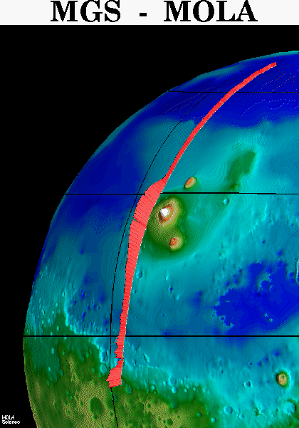
"Picket fence" rendition of surface topography in the northern
hemisphere of Mars from the Mars Orbiter Laser Altimeter (MOLA). The profile
was obtained during the Mars Global Surveyor Capture Orbit Calibration
Pass on September 15, 1997. The profile runs from 73°N to 10°S
latitude and passes through the topographically subdued northern plains,
the western part of the Elysium volcanic province, which shows 3 miles
(5 kilometers) of relief, and the chaotic "dichotomy" boundary
between the northern plains and ancient southern highlands. The MOLA profile
is approximately 3000 miles (5000 kilometers) long and has a resolution
on the surface of 1000 feet (330 meters) and a vertical resolution of approximately
3 feet (1 meter). (Credit: MOLA Science Team) |
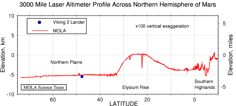
Topographic profile across the northern hemisphere of Mars from the
Mars Orbiter Laser Altimeter (MOLA). The profile was obtained during the
Mars Global Surveyor Capture Orbit Calibration Pass on September 15, 1997
and represents 20 minutes of data collection. The profile has a length
of approximately 3000 miles (5000 kilometers). The large bulge is the western
part of the Elysium rise, the second largest volcanic province on Mars,
and shows over 3 miles (5 kilometers) of vertical relief. This area contains
deep chasms that reflect tectonic, volcanic and erosional processes. In
contrast is the almost "featureless" northern plains region of
Mars, which shows only hundreds of meters of relief at scales the size
of the United States. Plotted for comparison is the elevation of the Viking
Lander 2 site, which is located 275 miles (445 kilometers) west of the
profile. At the southernmost extent of the trace is the transition from
the northern plains to the ancient southern highlands. Characterizing the
fine-scale nature of topography in this chaotic region is crucial to testing
theories for how the dichotomy between the geologically distinctive northern
lowlands and southern uplands formed and subsequently evolved. The spatial
resolution of the profile is approximately 1000 feet (330 meters) and the
vertical resolution is approximately 3 feet (1 meter). When the Mars Global
Surveyor mapping mission commences in March, 1998, the MOLA instrument
will collect 72 times as much data every day for a period of two years.
(Credit: MOLA Science Team)
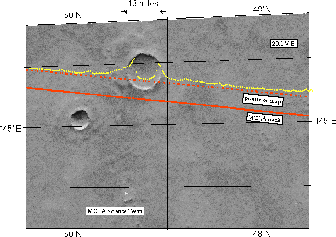
Among the myriad of interesting landforms sampled by MOLA on its first
traverse across the Red Planet on 15 September 1997 is this 13-mile (21-kilometer)
diameter impact crater located at ~ 48°N. The figure shows the topography,
the computed position of the spacecraft groundtrack (solid line) and the
track adjusted to correct for image location error (dashed line). The topographic
profile provides some of the first indications of how landscape modification
has operated in Martian geologic history. The relief of the crater rim,
in combination with the steepness (over 20°) of the inner crater wall,
are intriguing in that most craters of this size are much more subdued.
The shape of the outer ejecta blanket of the crater likely indicates impact
into an H2O-rich crust. Issues concerning how craters such as
this can be used to understand the properties of the uppermost crust of
Mars in regions where the role of water and other volatiles may be important
can be addressed with the high spatial and vertical resolution topographic
profiles that will be acquired by MOLA once it starts its detailed mapping
of the Red Planet in March of 1998.
(Credit: MOLA Science Team)
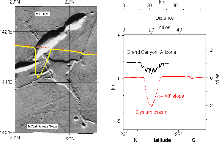
Comparison of the cross-sectional relief of the deepest portion of
the Grand Canyon (Arizona) on Earth versus a Mars Orbiter Laser Altimeter
(MOLA) view of a common type of chasm on Mars in the western Elysium region.
The MOLA profile was collected during the Mars Global Surveyor Capture
Orbit Calibration Pass on September 15, 1997. The Grand Canyon topography
is shown as a trace with a measurement every 295 feet (90 meters) along
track, while that from MOLA reflects measurements about every 970 feet
(400 meters) along track. The slopes of the steep inner canyon wall of
the Martian feature exceed the angle of repose, suggesting relative youth
and the potential for landslides. The inner wall slopes of the Grand Canyon
are less than those of the Martian chasm, reflecting the long period of
erosion necessary to form its mile-deep character on Earth.
(Credit: MOLA Science Team)
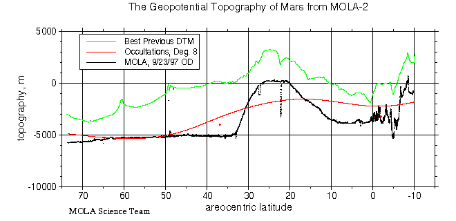
Comparison of Mars elevations from MOLA (black points) with previous
estimates of Mars topography along the groundtrack of the Mar Global Surveyor
Capture Orbit Science Pass. Shown is the USGS Digital Terrain Model [Wu
et al., 1991] (green line), an eighth degree and order spherical harmonic
model [Smith and Zuber, 1996] that emphasizes long wavelength vertical
control, and individual Mariner 9 and Viking orbiter occultation measurements
(red dots) that lie within about 100 km of the MOLA track [Smith and Zuber,
1996].
(Credit: MOLA Science Team)