
MGS MOC Release No. MOC2-260, 4 December 2000
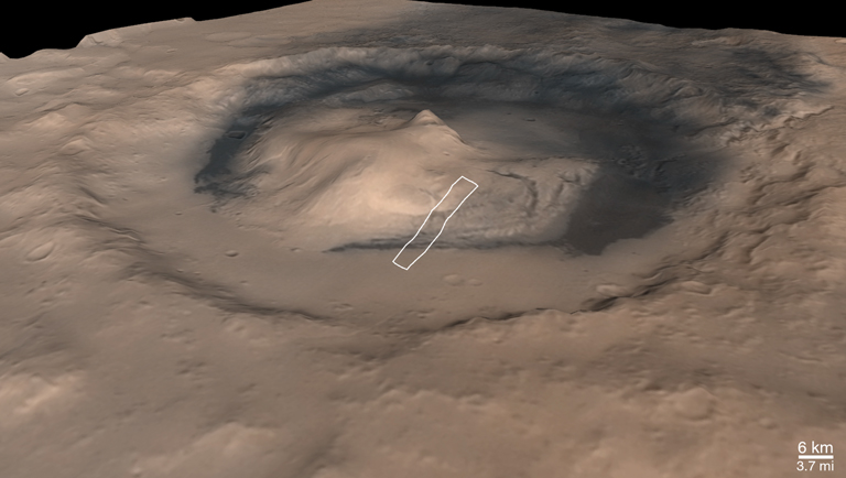 "Colorized" composite of MOC wide angle and MGS laser altimeter data, white box shows location of MOC narrow angle image M03-01521
|
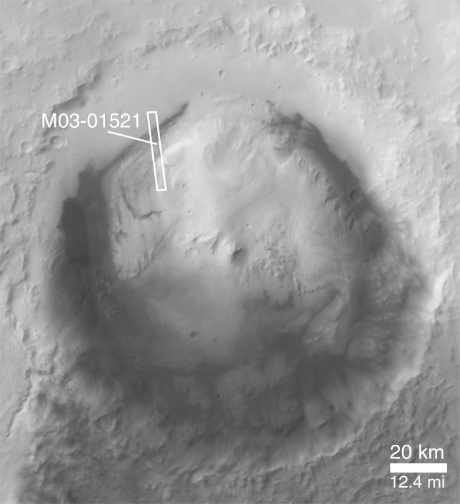 Cropped mosaic of MOC wide angle red images M01-00352 and M01-00740
|
|
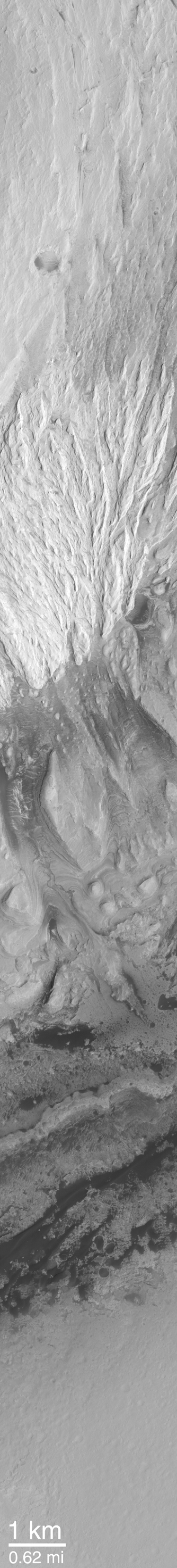
 Subframe MOC Image M03-01521
|
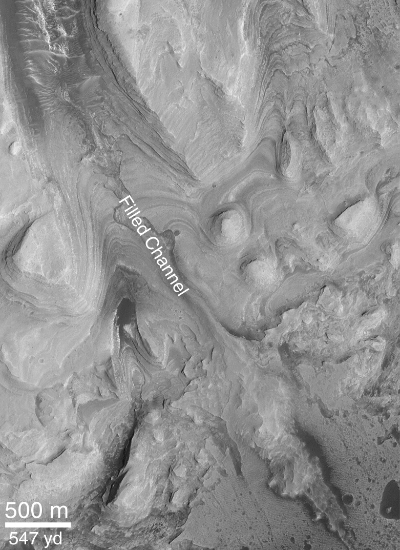
 Subframe MOC Image M03-01521
|
 Composite of Geologic Map based on MOC image M03-01521 (bottom) and MGS laser altimeter profile with vertical exaggeration of 2.5x
|
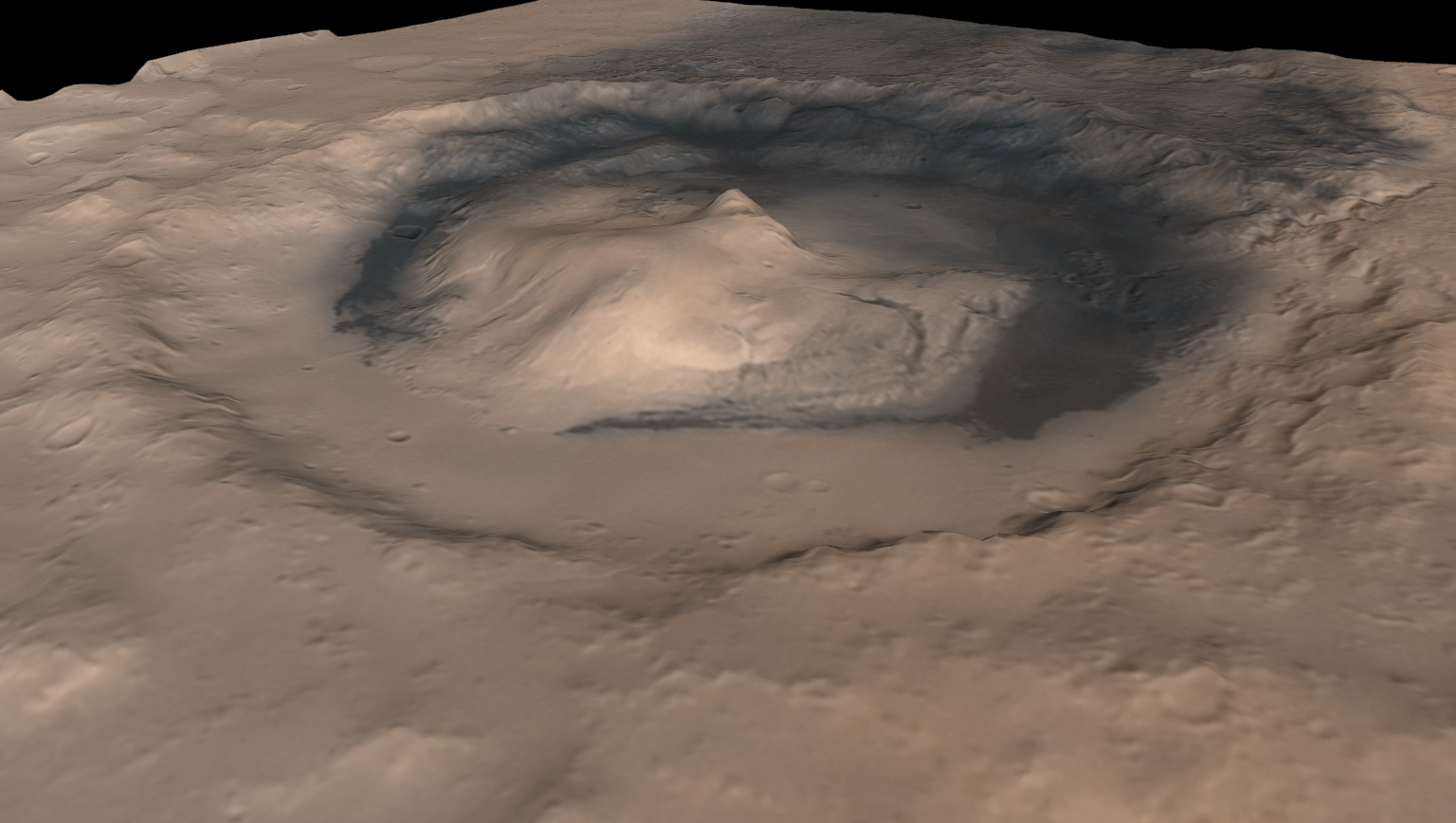
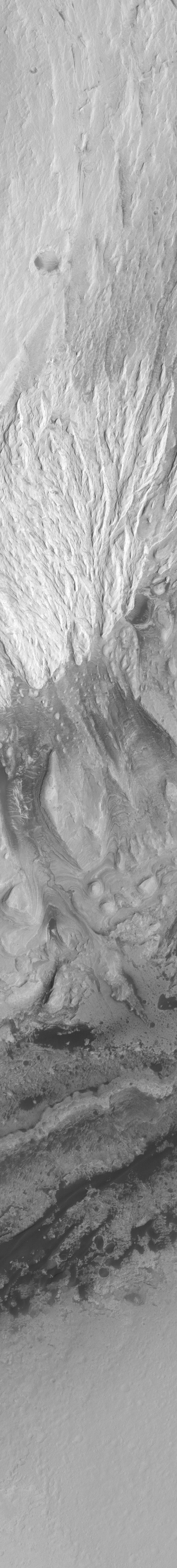
Picture A shows an oblique view---looking toward the southeast---of Gale Crater and its central mound that was generated by combining Mars Orbiter Camera (MOC) wide angle images with Mars Orbiter Laser Altimeter (MOLA) elevation data from the Mars Global Surveyor (MGS) spacecraft. The white box indicates the location of MOC narrow angle image M03-01521, which was used by MOC scientists to begin the process of deciphering the history recorded in the layers that make up the large central mound. This mound is thought to be a remnant of a once larger deposit that probably filled much or all of Gale Crater and perhaps extended onto the surrounding terrain.
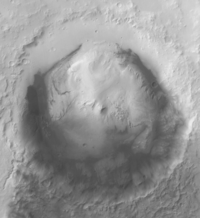
Picture B shows a view of Gale Crater looking straight-down from MGS's ~370 km-high (~230 mi-high) orbit. In this mosaic of MOC wide angle images, north is up, sunlight illuminates the scene from the upper left, and the location of the high resolution view, M03-01521, is again indicated by a white box. Other MOC high resolution views, such as M00-01602, show that the dark material surrounding the mound on the crater floor consists mainly of sand dunes.
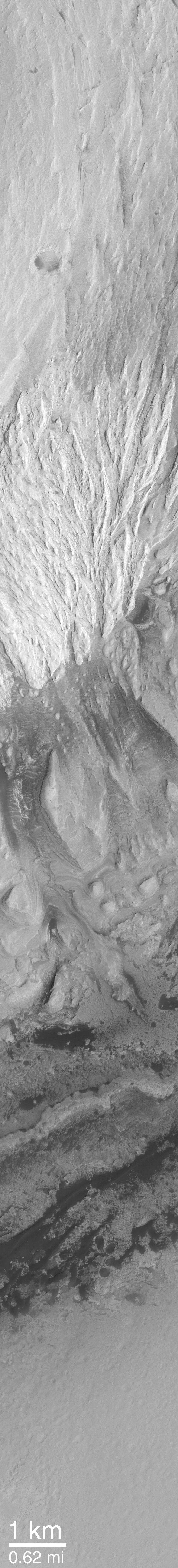
Picture C is the high resolution view, MOC image M03-01521, used to examine the details of layered rock exposed in the Gale Crater central mound. It is shown here with north toward the lower left (so it is oriented roughly the same as is seen in (A)) and illuminated by sunlight from the lower right. Dark sand dunes can be seen near the contact between the crater floor and the mound.
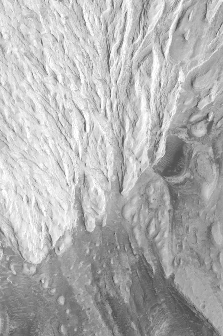
Picture D is a sub-frame taken from near the center of image M03-01521. Like Picture C, it is oriented with north toward the lower left. This area shows the thinly-bedded lower units of the Gale Crater mound. The lower part of the mound has hundreds of thin (2-5 meters; 2-5 yards thick) beds of similar thickness and properties---in this regard, the lower units are similar to the beds observed elsewhere on Mars, such as in southwestern Candor Chasma. The most striking feature in this sub-frame, however, is the area labeled "filled channel." This is interpreted to be a channel that was cut into the layered rock some time in the past. Perhaps it was cut by running water. Later, the channel was filled and then completely buried by additional sediment. At an even later time (closer to the present, but still very ancient), the material that buried the channel was stripped away, leaving a filled channel that, at its lower end (from center toward lower right) actually stands as a ridge higher than the surrounding terrain. This channel attests to the possible erosion of the layered rock by running water. It also indicates that there was a period in the past when the rock was eroded before being covered-up again. Such evidence and interpretations are pieces of the story of this area.
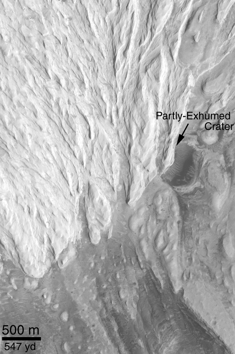
Picture E continues the theme of things eroded, things covered up, and then exposed again. The circular feature labeled, "Partly-Exhumed Crater," is interpreted to be an ancient impact crater that formed on the same layered rock surface into which the channel in Picture D was cut. This crater, like the channel in Picture D, indicates that the layered rock was exposed to the atmosphere for some period of time before the next layer of material---the bright, almost white ridged rock that covers most of the upper half of this picture---was deposited. In this scenario, the sedimentation ceased long enough for the lower rocks seen here to remain exposed, so that meteorites could hit the surface and form craters. These craters were then buried by the bright material that still covers about 1/3 of the partly-exhumed crater in this scene. When an ancient erosion surface, such as that into which the crater formed, is buried by additional layers of material, a gap in the geologic record is created. Geologists call a gap such as this an erosional unconformity.
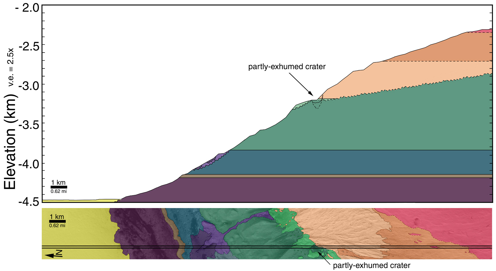
Picture F is an interpreted cross-section through the part of the Gale Crater mound that is visible in MOC image M03-01521. The lower part of Picture F is the image, M03-01521, with each different rock unit (some have many, thin layers, others have few layers, others erode differently or have different brightness, etc.) shown by a different color. The cross section uses the MOLA topographic profile that was acquired by MGS at the same time as the MOC image. The MOLA data give elevations for the area between the two straight black lines running lengthwise across the MOC image. Where the MOLA profile intersects the contact between each colored unit, the position of this unit in the cross section can be inferred. These data and the observations presented in Pictures D and E show that the Gale Crater mound preserves a complex history that includes the formation of many layers in the lower part of the mound, a period of erosion and cratering on these lower layered units, then deposition on top of these materials by younger, brighter, and not-layered (i.e., massive) units.
(A) Oblique View Looking Southeastward Across Gale Crater and Central Mound
(B) Gale Crater Context Image, North is Up:
(C) M03-01521:
(D) Layered Units and Filled Channel:
(E) Massive Unit and Partly-Exhumed Crater:
(F) Stratigraphic Cross Section of Gale Crater Mound:
Malin Space Science Systems and the California Institute of Technology built the MOC using spare hardware from the Mars Observer mission. MSSS operates the camera from its facilities in San Diego, CA. The Jet Propulsion Laboratory's Mars Surveyor Operations Project operates the Mars Global Surveyor spacecraft with its industrial partner, Lockheed Martin Astronautics, from facilities in Pasadena, CA and Denver, CO.
 To MSSS Home Page